Infrastructure projects are inherently complex and demand a highly coordinated, data-driven approach. From highways and rail corridors to utilities, drainage, and urban development, every infrastructure venture spans large geographic areas and interacts with varied topographical and environmental conditions. Traditional methods of managing civil infrastructure design and construction are no longer sufficient to meet today’s demands for precision, sustainability, and efficient delivery.
At AI Engineers, we deploy advanced BIM for Infrastructure services to streamline planning, design, execution, and maintenance for civil engineering and infrastructure projects. Leveraging intelligent 3D modeling integrated with time, cost, and asset management data, our BIM solutions offer project teams greater control, transparency, and insight across the project lifecycle.
Why BIM is Crucial for Infrastructure Projects
Infrastructure projects are multidimensional and involve multiple disciplines—civil, structural, geotechnical, environmental, and MEP—working in tandem across extended timeframes. With traditional CAD-based systems, discrepancies between disciplines, data fragmentation, and manual coordination frequently lead to costly rework and project delays.
BIM for Infrastructure mitigates these risks by integrating all data, design, and processes into a centralized digital environment. From conceptual planning to final execution and facility management, BIM improves design accuracy, enhances collaboration, and enables smarter decision-making.
Key Applications of Infrastructure BIM
1. Site Development and Grading
Using BIM-integrated tools such as Autodesk Civil 3D, our team models terrain surfaces, slope analyses, and grading plans with high precision. Site grading models factor in drainage patterns, erosion control, cut-and-fill balancing, and construction staging.
2. Roadway and Highway Design
BIM models help generate corridor models for roads, highways, and interchanges, incorporating alignment geometry, cross-sections, and earthworks. BIM also supports visual phasing of construction sequences and helps identify utility clashes early in the design phase.
3. Rail and Transit Infrastructure
BIM for rail includes alignment modeling, track layout, tunnel design, platform modeling, and integration with structural and MEP systems in stations. The 3D models support clash detection, cost optimization, and timeline planning.
4. Water, Sewer, and Stormwater Systems
AI Engineers offers precise modeling for underground utilities, including water supply, storm drainage, and wastewater pipelines. BIM enables hydraulic simulation integration, clash detection with existing infrastructure, and accurate coordination with surface-level construction.
5. Bridges and Tunnels
Complex structures like bridges and tunnels benefit from detailed geometry modeling, reinforcement detailing, and coordination with substructure and superstructure elements. BIM allows for sequencing, stress simulation, and integration with transportation networks.
Deliverables and Services We Offer
Our BIM for Infrastructure solutions include the following specialized deliverables tailored to large-scale civil engineering projects:
Digital Terrain Models (DTM)
Topographic surveys are processed to generate highly accurate digital terrain and surface models used in route alignment, grading, and earthworks analysis.
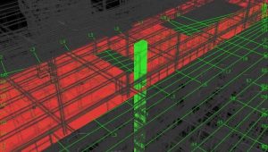
Clash Detection and Coordination
Multi-disciplinary clash detection ensures MEP utilities do not interfere with structural or civil elements. This improves coordination between consultants, contractors, and public utilities before construction begins.
Detailed Construction Drawings
From alignment drawings to pavement markings and pipe network details, we provide IFC-ready drawings that meet global standards and ensure field accuracy.
Fabrication Drawings for Precast & Steel
For prefabricated or modular infrastructure components, we deliver high-precision shop drawings and assembly plans to accelerate manufacturing and installation.
As-Built Modeling and Digital Handover
Our team supports construction documentation and generates as-built BIM models to represent the built asset accurately, incorporating all on-site changes and RFI resolutions.
4D and 5D BIM for Civil Infrastructure
We enable time-based construction sequencing and cost estimation tied directly to the infrastructure model. This improves resource planning, budget tracking, and execution accuracy.
Asset & Facility Management Data Integration
Our 6D BIM solutions integrate operation and maintenance data for future facility management, lifecycle tracking, and intelligent infrastructure asset management systems.
Technologies and Tools We Use
AI Engineers uses industry-standard software for Infrastructure BIM, including:
- Autodesk Civil 3D – Roadway design, grading, pipe networks, and corridor modeling
- Revit + Navisworks – Coordination, clash detection, and 4D sequencing
- InfraWorks – Conceptual planning and visualization
- Autodesk Recap – Point cloud processing for as-built verification
- Bentley OpenRoads/OpenBridge – Advanced transportation and structural modeling
- AutoCAD Plant 3D – For utility, water treatment, and pump station modeling
Our proficiency in open BIM standards like IFC, LandXML, and COBie ensures interoperability across teams, platforms, and lifecycle systems.
Advantages of Using BIM in Infrastructure Projects
Improved Accuracy and Planning
Civil models generated through BIM are far more accurate than traditional 2D CAD drawings. This reduces design ambiguity, enhances stakeholder understanding, and decreases rework during construction.
Enhanced Interdisciplinary Collaboration
All stakeholders – engineers, contractors, surveyors, and authorities – can work in a shared environment with version-controlled models and integrated data sets
Real-Time Data Visualization
Through simulation and visualization, BIM communicates complex designs in a clear, easy-to-understand manner, especially for non-technical stakeholders and public approval processes.
Lifecycle Value and Maintenance Efficiency
Data-rich models help infrastructure owners plan future upgrades, track asset condition, and improve maintenance schedules based on historical and real-time performance data.
Sustainability and Environmental Analysis
Integrated environmental data and simulation tools support better ecological decision-making, such as optimizing runoff systems, reducing energy consumption, and minimizing material waste.
Project Use Cases
Urban Road Redevelopment
In a congested metro project, AI Engineers used BIM for corridor modeling, pedestrian walkway design, and utility relocation, minimizing service disruptions and expediting approvals.
Airport Drainage System Upgrade
We implemented BIM for hydrological modeling and underground drainage, resolving utility clashes and enabling precise phasing in coordination with ongoing terminal operations.
Smart City Utility Mapping
Our team developed a federated BIM model for water, sewer, gas, and fiber optics across 18 sq. km of urban space, streamlining smart city operations and digital twin development.
Future-Ready Infrastructure with AI Engineers
With increasing global focus on resilient infrastructure, climate adaptation, and smart cities, BIM is becoming indispensable for civil and infrastructure projects. At AI Engineers, we combine domain expertise with cutting-edge digital workflows to deliver high-performing infrastructure outcomes—from concept to completion and beyond.
Our Infrastructure BIM Services are designed not only to enhance project delivery but to ensure long-term asset value, stakeholder trust, and environmental sustainability. Whether you are planning a highway, metro system, utility network, or water treatment facility, our BIM-enabled approach ensures reduced risk, improved precision, and successful project execution.